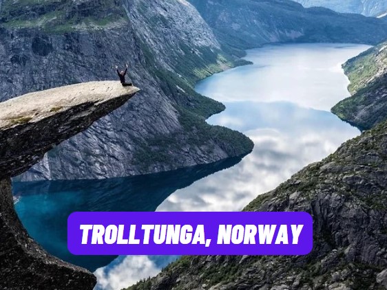
Trolltunga, Norway
The Trolltunga is a spectacular rock formation that extends like a tongue drawn above the void! This vertiginous cliff overlooks Lake Ringedalsvatnet in the county of Vestland in southwestern Norway. . A spectacular hike leads you to this spot which overlooks the void. Tunga means "Language", so we can translate Trolltunga as " troll language "!
This impressive place attracts crowds of travelers who want to get dizzy and have their photo taken in this Norwegian panorama that gives thrills just by looking at it.
- Map of Trolltunga in Norway
- How to reach the Trolltunga?
- Map of the Trolltunga trek
- Where to stay in Odda
- When to go to Trolltunga
Map of Trolltunga in Norway
The map below allows you to locate the Trolltunga in Norway, near the town of Odda located in the South West of Norway. Trolltunga belongs to the Norwegian county of Vestland, east-southeast of Bergen
How to reach the Trolltunga?
Reaching Trolltunga requires a 5-hour hike for an ascent of around 900 meters.
Trolltunga is relatively difficult to reach and is aimed at an audience in good physical condition. This dizzying cliff is perched about 1100 meters above sea level and overlooks Ringedalsvatnet Lake 700 meters high.
To admire this masterpiece of nature, go to the county of Hordaland.
You will have to start from Skjeggedal (in the municipality of Tyssedal) to join the high mountain path that leads to Trolltunga. Skjeggedal is a small village located on the northern shore of Lake Vetlevatnet. It is part of the municipality of Ullensvang in the county of Vestland, about 5 kilometers northeast of the village of Tyssedal and about 10 kilometers northwest of the town of Odda.
➜ If you do not have your vehicle, the best served city (train or bus) is Odda . But it's an obstacle course to get there by public transport, so choose a rental car from Oslo.
➜ To realize this Norwegian dream you can set off for 8 days for spectacular hikes , ask for a quote so that we can prepare your adventure for you, it is not binding.
Map of the Trolltunga trek
Below is the map that allows you to visualize the hiking/trekking path from Skjeggedal to Trolltunga. The hike lasts 5 hours and is punctuated by multiple sites, including the Ringedal dam and the circular cavities of Rullestad.
Where to stay in Odda?
The city of Odda, gateway to Trolltunga, is an amazing city because it shelters, in a sumptuous setting, a working-class city that lives off heavy industry. Developed around foundries built at the head of the Sørfjord, Odda's industries attracted migrants from different parts of Norway. The factory was, when it was built, one of the largest in the world! So it's a special atmosphere.
When to go to Trolltunga?
You can visit Trolltunga all year round. But it is from mid-June until mid-September that we benefit from the best climatic conditions.
The hikes are generally done from June to August. The rest of the year, it is also possible to do the route on snowshoes to admire Trolltunga under the snow.


Post a Comment for "Trolltunga, Norway"